Fforest Fawr Geopark
Pontneddfechan, South Wales
Alan Bowring
Wednesday 6th May 2015
Following the lecture in March by Alan Bowring, 42 members went on an excursion to the Waterfalls Centre at Pontneddfechan. Situated on the southern flanks of the Brecon Beacons, the centre is at the heart of the Fforest Fawr Geopark established in 2005. Geoparks are part of an international network created to celebrate sites of important geological interest and a human contribution in the form of legends, culture, archaeology and the relationship between man and land. The Geopark covers the western half of the Brecon Beacons. This extensive tract of moorland was once a Norman royal hunting ground; known for centuries as Fforest Fawr – the ‘Great Forest’.
The sedimentary rocks in this part of South Wales were formed during the Carboniferous Period 359-299 million years ago. During this period Britain lay more or less on the Equator and so enjoyed a tropical climate, and a large depositional environment. At the start of the Carboniferous sea levels rose and former river plains were flooded to form a shallow, warm sea that extended across much of South Wales, ideal conditions for the growth of corals and brachiopods to thrive.
In time the shallow seas were once again inundated with sand and mud brought down by rivers from the Caledonian Mountains to the north. Later river deltas were colonized by plants and dense swampy forests formed.
Towards the end of the Carboniferous a period of mountain building took place, the ‘Variscan Orogeny’. This arose from the collision to the south of Wales, of the micro-continents of Armorica and Iberica with Laurussia. Rock layers were deformed and uplifted evident in the generally southward dipping strata.
During the last 2 million years a period of alternating advance and retreat of ice sheets has taken place. Consequential uplift of the land has caused rivers to cut valleys with some vigour, creating steep sides and in some places gorges. The river courses are superimposed on the geology, which explains the positions of waterfalls and rapids.
In the Fforest Fawr Geopark the Carboniferous rocks are divided into three layers. The lowermost the Limestones, being the first to have been formed, succeeded by the Marros Group and then the Coal Measures:
South Wales Coal Measures – up to 1200m thickness of mudstones and sandstones with coal seams.
Marros Group – up to 130m thickness of mudstones and sandstones. The rocks of the Marros Group were formerly known as the ‘Millstone Grit Series’. The oldest rock in this layer is the Basal Grit, made up of quartz rich sandstone and conglomerate. The youngest part is the Shale Group, comprising shales and thin bands of sandstone e.g. the Twelve Foot Sandstone and the Cumbriense Quartzite. The Shale Group lies beneath a thicker sandstone band known as the Farewell Rock. This was of significance to miners as it marked the end of their interest in the Basal Grits as below this layer there were no more ironstones or coal. The Farewell Rock is synominous with a prolonged period of coastal plain conditions to be found at the base of the Coal Measures.
Carboniferous Limestone Series – up to 180m thickness of limestone and some sandstone and shale.
Two walks were organised and led by Geopark centre staff.
Walk 1: alongside the Rivers Neath (Afon Nedd) and Pyrddin, culminating at the Sgwd Gwladus waterfall.
The walk began at the top of the geological sequence with the Farewell Rock. A hard sandstone and shale layer, representing a period of lowered sea level and the development of a coastal plain. Noteworthy features included a fossilized river channel log-jam of Calamites and cross-bedding showing that currents flowed from north to south.
Beneath the Farewell Rock the Shale Group comprises two hard sandstone bands. One band, the Cumbriense Quartzite, is mixed with shale where plant fossils are abundant. The second band is the Twelve Foot Sandstone whose top surface is cracked and jointed.
Further up the valley, and underlying the Shale Group is the Basal Grit. Used for millstones, the pure grit is quartz/silica rich, and was mined to make bricks for lining furnaces. The horizontal adits along the path mark the positions of the mines. Whereas a conglomerate contains plant fossils of stems, trunks and roots.
At the top of the valley the Twelve Foot Sandstone forms a ledge over which the Sgwd Gwladus waterfall cascades. The base of the Twelve Foot Sandstone is evident here as a sharp but undulating surface indicating erosion of the sea floor before the sands were deposited. Above the waterfall the top surface of this layer is apparent as a smooth, pale, hard quartzite with fossil roots of Stigmaria indicating that this surface became emergent and was colonised by plants.
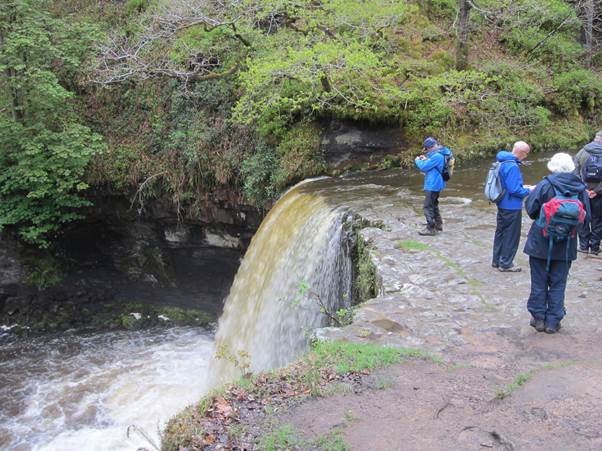
Sgwd Gwladus waterfall
Walk 2: took in Craig y Dinas, Bwa Maen, a silica mine and the old Gunpowder Works.
During the early part of the Carboniferous 359 million years ago ‘Britain’ lay on the Equator as a large, tropical, shallow sea. A distinctive Karst landscape of caves and pavement has developed from the resulting limestone formation. The limestone has been of economic importance as quarries and kilns are evidence of the rock having been mined/processed for mortar, agriculture and as a flux in the iron, steel and tin industries.
The walk took in Craig y Dinas (Dinas Rock) at the head of the Vale of Neath. Lying along the Neath Disturbance, an east-west aligned fault system created during the earlier Caledonian Orogeny. The fault extends to take in Bwa Maen and continues to the valley north of the Sugar Loaf towards Hereford, and is the most southerly of all the great Caledonide faults. The rocks dip at 70° because of subsequent pressure from the Variscan Orogeny on whose northern flank they are positioned. Bwa Maen shows the folding in truly spectacular style with an arched fold exhibited in the rocks.

Dinas Rock
The Silica Mine was operational from the late 18th century until 1964. The Basal Grit quartzite was mined at Craig y Dinas because of the more or less pure silica (SiO2) content. The refractory firebricks manufactured from this silica were transported world wide, and in Russia firebricks are still called ‘Dinas’. The transportation method via tramroads is still evident.
The concluding part of this walk was the Gunpowder Works. The works at Pontneddfechan was established in 1857 to supply explosives for use in the coalfields of South Wales and the slate industry in North Wales. The site was chosen for the ready availability of water for power, wood for charcoal a key ingredient and its remoteness, in view of the hazardous nature of the industry. The two other ingredients, saltpetre and sulphur were brought to the site via a tramway. The site was closed in 1931, after the Home Office took black powder off the ‘permitted list of explosives’.